
The local-first operating system for the sea.
We are building Meridian* to fuse charts, weather routing, radar, and vessel data into a single pane of glass. It runs completely on edge hardware—shifting from photorealistic 3D terrain when connected to cached high-fidelity maps when offline—with zero central latency, no cloud dependencies, and no phoning home.
Marine electronics are a decade behind, built on fragmented apps and fragile cloud dependencies. We are building Meridian to prove a point: that local-first, autonomous infrastructure isn't just a theoretical ideal—it's a survival trait.
Routes around islands.
Full ensemble weather routing on edge hardware. 51 members calculating optimal passages from real wind, currents, and polars—running entirely on your local hardware.
Talk to your boat.
A local agent monitors the VHF, transcribes every transmission, and responds to your direct voice commands—"how are we tracking?", "show me the starboard tank on the galley screen." One tap to confirm. Never auto-transmits.
Works offline.
Cached charts, local LLMs, and deterministic voice control. Everything works mid-ocean, sky dark, zero bars of Starlink.
Every layer of the sea, on one screen.
Toggle forecast fields, currents, storms, and satellite overlays. Your real, measured wind sits in cyan at the bow—never blended or averaged with predictions. Tap a destination, and Meridian pre-loads the entire landfall payload (charts, anchorages, and local knowledge) before you drop the horizon.
And then come the layers you write yourself: custom agentic layers built from notes left in harbors, observations from other sailors, sensors mounted on your hull, and live boat data piped in over Signal K. The glass is the surface. The layers are infinite.
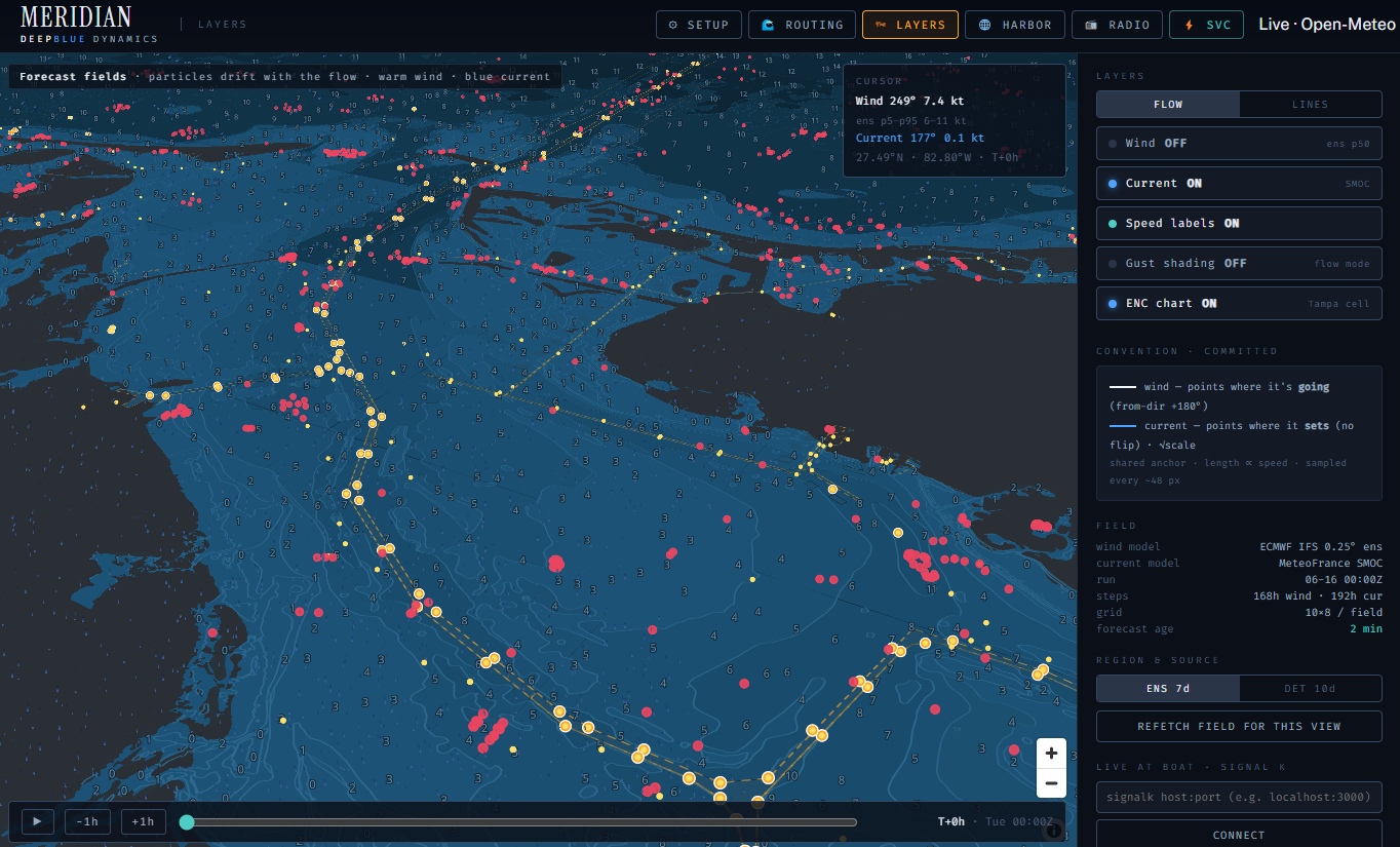 WIND · CURRENT ×7 · MEASURED
Feed-forward routing that learns your boat.
Traditional routing relies on flat manufacturer spreadsheet charts—idealized numbers calculated for a clean hull, flat water, and a robotic helm (ahem). They are purely reactive feedback systems. We are replacing passive assumptions with an evolving feed-forward envelope: a live model of how your specific vessel actually moves through the water, ready for the router to plan against.
Pull a baseline profile from our global network of crawled hull designs, displacements, and characteristics to match your vessel.
Tap the UI to activate your current sail plan—whether you are flying a code zero or a deep-reefed main in a heavy blow.
Once engaged, Meridian continuously measures how your canvas, displacement, and helming style interact with live currents and sea states.
Instead of waiting for the boat to drop speed over a wave, the local engine updates its internal isochrone model in real time. It predicts the dynamic lag of your boat through upcoming chop, optimizing your routing matrix before the hull even hits the next wave. It is the foresight of an elite helmsman, scaled across a 72-hour passage.
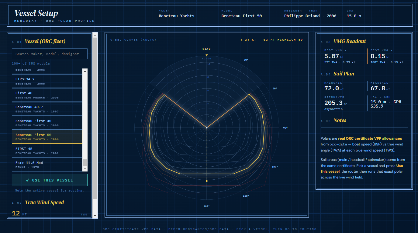 ISOCHRONE · ENSEMBLE TUNING · 72 HR HORIZON
Isochrone routing.
This isn't a static rhumb line with a wind arrow. Ensemble weather routing solves your passage against fifty-one slightly different versions of the forecast at once. Each member plots its own optimal track around the Gulf Stream push, the blow, the land—and the spread across all fifty-one is your live risk picture.
We hand the tuned envelope from the previous section to every member of that ensemble. The router stops planning a generic textbook boat and plans your boat—this hull, this displacement, this canvas, this helmsman. The question changes from "what would a boat do here?" to "what will you do here?"
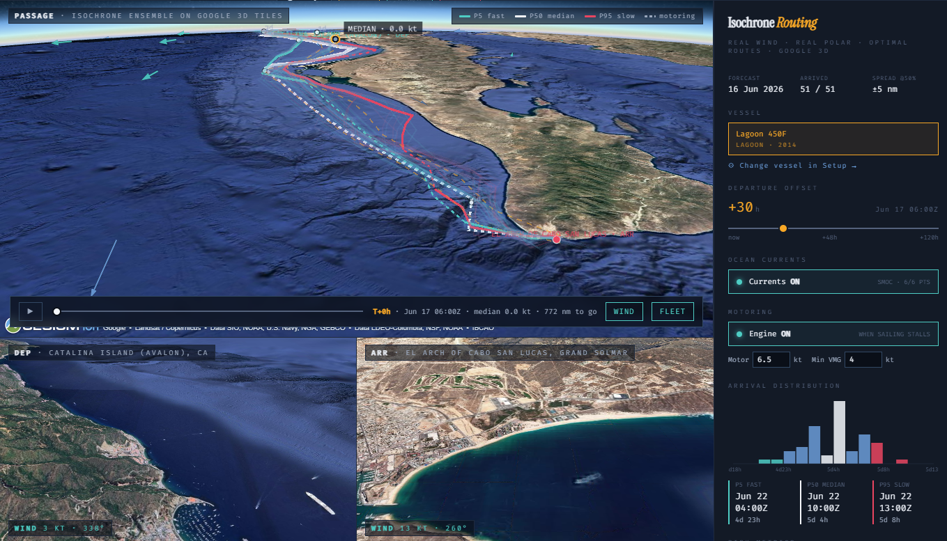 ENSEMBLE · P5 / P50 / P95
The handset is the copilot.
We are building Meridian to monitor the VHF, detect voice activity, record the audio, and transcribe it directly into a local logbook. Years of radio traffic, instantly searchable.
The same engine that hears the radio hears you. Hold the handset and ask—"show wind", "hide current", "jump three days forward", "what's at the next anchorage?"—and Meridian acts on it: toggles the layers, replans the route, surfaces the chart. The VHF mic you already own becomes the steering wheel for everything on the glass.
The maritime edge of the Fleet.
Meridian represents the maritime edge of The Fleet, running on the sovereign, agentic infrastructure we are building for everyday computing—pointed at the ocean.
Hyperia
An open source surface where terminals, shells, and agents come together—on your hardware. Run one. Or let one run many. The bridge of the vessel.
Nemesis 8
The multi-provider agent orchestrator. It spins up sealed Docker environments per session, runs the tool catalog, and persists state across reboots—the actual engine running the Bridge.
NUTS.SERVICES
Open source agentic microservices for weather, current, routing, customized layers, document indexing and more.
We build in the open. Come watch.
We build in the open. We are putting the entire development process on camera—the routing algorithms, the voice compilation, the local model optimization, and the failures. Come watch a single engineer out-build a billion-dollar industry.